A year ago a wonderful friend of mine challenged me to book myself a holiday, to do something for me, something I could plan and look forward to. She gave me 6 weeks (while she was on holidays) to come up with something. For 5 weeks I was lost! I hadn’t ever chosen a holiday for myself! I’d gone to races and fought fires and been on flood rescue standby or joined other people’s holidays, but never chosen my own. With a week to go before my deadline my friend Thuy said she wanted to do Hubert 160km in South Australia in 2019. Sweet I thought, I’ve never been to the Flinders Ranges, and I’ve been yearning to do another 100km run- I’m going on a road trip!
11 months of training began. First a strength and base phase as I’d only been doing 45km races recently, then some volume (over a long hot summer!) and finally a bit of speed and more strength as I lose strength easily if I don’t work on it.
Finally time appeared to speed up and taper was upon us. I had pages of lists of what to pack, and had planned a fun and educational 4 day journey across NSW for myself and my 9 year old wingman. We spent two days at Dubbo Zoo, time in Nyngan and a day in Broken Hill before cruising our way through small South Australian towns to Rawnsley Station in the Ikara Flinders Ranges.
My Dad came from Perth to join us and Thuy and her partner Brian flew over too. We spent the first day checking and re-checking drop bags and checking in at Wilpena Pound Resort, and made sure we had our meals for the first few days planned and prepared.
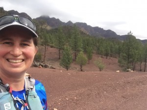
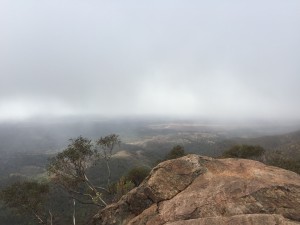
Race morning I was ready and sat calmly at the start line keeping warm and watching all the other runners chat with excitement. We were off at 8am (the 160km didn’t start until 10am) and I spent the first 10km shuffling things around in my pack and finding the best place for the heavy GPS tracker we had to carry. Once we started to climb up the rocky single trail to the saddle I was warmed up and ready for some fun! I’m not normally an uphill person but I guess I’d trained specifically for this gradient for 11 months and at home the hills are generally longer and steeper if not as rocky. I started to pass people and have a chat to them. It was a misty, drizzly morning (not something I was prepared for coming to the outback!) and the hills inside the pound looked more like a mini British moor than the rugged outback ranges.
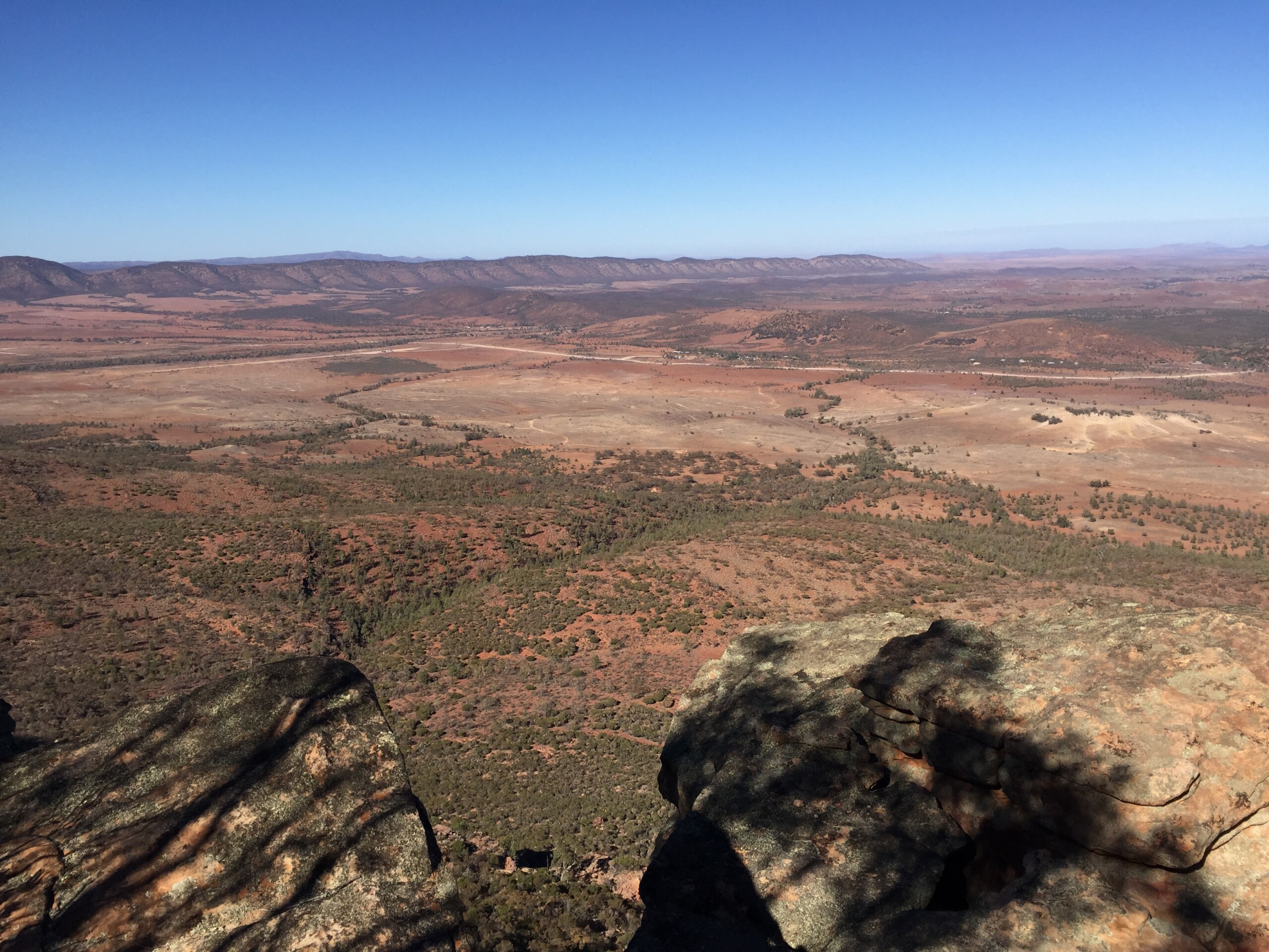
Once we hit the top of the climb we looked over the edge and had a ‘what the?’ moment. The map we had been given wasn’t a topographic, so although we had seen an elevation profile on the website, it was hard to realise what the terrain was actually like until you got there. We had to scale down the cliff, which was more like something I’d expect at Blackheath in the Blue Mountains than the smaller hills here. I embraced the decent and smoked my glutes enjoying the challenge but I was thinking of my 4ft high friend and how she was going to lower herself down!
At the bottom I had a bit of a trip and landed heavily on my right foot. It wasn’t injured as such, but it reminded me that with this much rock on the trail I did not want to face plant.
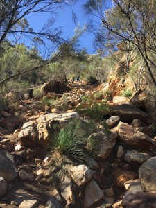
After the first checkpoint we had some easy open paddocks and fire trail. Still plenty of rocks, but nice and undulating, and it was still a cool morning. I got used to the marking system and from that moment made sure I didn’t move forward unless I could either see a definite trail or the next marker. In the open sections there were animal tracks going everywhere, so it was hard to know which one to follow. In the rocky sections there was no visible trail at all. You really did need to be able to see the next marker to know you were on the right track. The course notes told us which trail marker to follow on each section, now we were on the Heyson Trail!
At the 34km mark I didn’t feel too bad. It was amazing to think that I was already a third of the way through! I refilled everything for a longer section to the next checkpoint, the aid station people were helping a poor fellow who had not been so lucky on the rocks and was covered in blood. The event crew were fantastic, so friendly and helpful! We certainly felt well looked after at every checkpoint and at the start and finish line.
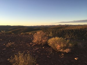
Next was a gravel road that was hot and full of flies! This is where I had to use all my mental strategies to keep going at a decent pace. I’ve had plenty of experience in endurance sport, and I’m a personal trainer and wellness coach, so it sometimes can be hard to use positive psychology on yourself, because you know you’re doing it! However, as much as long flat-ish roads are not my thing, I wanted to get as much as I could done in the daylight, and the heat and flies weren’t going to be any less bearable at a jog than at a walk anyway! I persevered with eating my gluten-free vegemite sandwich and just kept moving forward. The saving grace of this section was the surrounding scenery! We had the main range on the west looking just like a postcard and a row of rugged razorback hills on the east (more on these later!). I hit 45km in 7hrs, and then 50km in under 8hrs. I was really happy with this as I was hoping for a sub-18hr finish (Leonie Waldron knows why) and this would give me some wriggle room once I got fatigued and hit the infamous ‘creek section’ in the dark.
I was pretty happy to see Aroona checkpoint, not only because checkpoints break things up mentally, but because 4pm meant a drop in temperature and a change in terrain. The guys had potatoes, which was wonderful because us glutards can’t eat a lot of aid station food so I grabbed one of them and all my mandatory gear, filled a bag with some nibbles and grabbed my first coke of the day. The combination of cooler temperatures, no flies, a lovely hill climb and the caffeine was magic and I had a ball on the 14km section to Trezone. I gobbled up the hill and trotted down the rocky single trail, even passing a few people who were enjoying the hill a little less than me. I was all alone for this section, it was dusk and it was beautiful! I had done 60km in under 10hrs and had up to 8 hrs to do 40km and hit my goal- very achievable I thought! I had hoped to pass Thuy on this section. The 160km did the loop anticlockwise, we did it clockwise, and they did a couple of extra bits as well. Just before the next checkpoint there was a river bed to cross- Stephen Redfern had warned us of the ‘creek sections’ so I made a note to tell Thuy when I saw her where to look for the markers,…. If only I had known!
At Trezone the lovely volunteers were looking after a fellow who wasn’t feeling great. Last year he had timed out and been extracted in a sorry state after getting hopelessly lost in the ‘creek section’ so he wasn’t looking forward to navigating it again in the dark. I cheerfully invited him to do that section with me, I was feeling pretty strong, had good momentum and navigation is something I have an interest in. Once I found the trail head I set off across the first paddocks and he caught me not long after, feeling better after some soup and with some company. Along this section we finally saw Thuy. She was a good 2hrs behind schedule and had just been lost for 2hrs in the creek section,… she warned us not to go anywhere unless we could find the next marker and raced off to try to make up the lost time. Once we hit the ‘creek section’ we found out what she meant. The notes said ‘this section is hard to navigate, follow the Heysen trail’. However, the Heyson trail was not visible under our feet in the dark due to the aforementioned animal tracks and rocks and the markers were 200m apart, so if there were trees or rocks or a bend in the trail or an up or a down you couldn’t see the next one. The event organisers had put some short red tape in some trees with a metallic ribbon, but it wasn’t reflective by torchlight until you were actually right up beside it and we had no moon. Maybe the red tape would have worked well in the daylight for the 160km front runners and the 50km people the next day, but not for us.
We slowly worked together to get through what we now realised were the rugged razorback hills and valleys we’d seen on the way out. The rock was pushed up on a 45 degree angle millions of years ago and we were trotting along the edges of these rocks. We worked a system where I went ahead and Michael would wait at the marker until I found the next one and called him forward. If I couldn’t find it he would look in another direction and call me back. It worked but it was slow going, we were losing momentum and cooling down. One particular creek bed we had to follow forked and meandered so we scrambled over rocks trying to find the dark coloured hanging ribbons in the dark creek bed without taking the wrong turn.
Finally, after doing 24minute/km for what felt like forever we hit a trail, then a track and then when we turned onto a single trail again up a decent hill I made sure Michael got on the right trail and kept hiking on without him. He was starting to crash again and needed the aid station. With all the effort of navigating and trying to stay on track he hadn’t been sucking on his water or nibbling on his food. I’d dropped my GF sandwich in the process as well so I was keen to get to some decent food too. I was still strong. I knew I’d lost enough time to forget my sub-18hr dreams so now I just wanted to finish in good shape. After a hill and another dreaded creek bed I got to Wilcolo aid station.
I had a little melt down, that last section had been demoralising and not very fun (although I bet it is in daylight! I love technical terrain normally!). I had a bucket of potatoes and convinced the paramedic I was ok to continue by telling her a bad joke: ‘Why can’t an elephant ride a bicycle? Because it doesn’t have a thumb to ring the bell!’ She let me go.
I only had 15km to go, even if I walked it out I’d be done in less than 3hrs. I had my watch on a portable charger (because if it’s not on Strava it didn’t happen and that would be the LAST straw!) and I had a full belly again. Alas things did deteriorate from here and I was trying with all my might to be positive and not let setbacks get me down. To be honest I was really strong mentally, just disappointed. With 6km to go I realised my phone had fallen out of my pack so I had no offline map and the event map was just a blue line on a white page with no topographical features so couldn’t be used to navigate. I had a good mental map of this section so I stayed calm and worked extra hard at trying to find markers and remember the direction I had to go. The good old Southern Cross helped remind me I was going in the right direction.
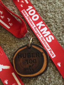
Finally I got to the last aid station with 1km to go. I told the ladies I’d lost my phone and hoped that someone would pick it up later in the night or in the 50km event the next day (someone did the next day, thank goodness because we all dread losing our phones with all the fabulous photos on them!). The checkpoint ladies knew I didn’t have the online map so walked me to the gap in the fence and pointed me South. There were no actual markers here. I got to a point where I found a red cross and didn’t want to head off around Wilpena Pound again, but back-tracking I couldn’t find the track. Everyone except the runners could see where we were by tracking our GPS. I had no phone, no map and no markers. I didn’t want to call out because I didn’t really need help as such, but I just needed to find the single track I needed to get to the finish line. Eventually the checkpoint ladies came and found me (they must have seen me wandering around on the tracking app) and pointed me through to the next turn and the single track to the finish line. I was done! 102.3km in 19:07hrs, longer than I’d hoped, but certainly given the challenges I was happy to have finished.
Sitting by the fire I was quizzed by the paramedic and assured him I was cognitively and metabolically fine, emotionally less so! He laughed. Here I found out that Thuy had managed to get through to Aroona without mishap but had gone wrong again on her next section. She would be eliminated so we would have to send Brian to pick her up in a few hours once the checkpoint people came back in. She’d done an amazing job, was physically fine and certainly had 160km in her that day even if she’d only had a chance to do 95km.
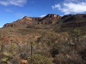
I told my Dad I was never doing 100km again. Everything was seized up and hurt. My right ankle hurt from the stumble I had that morning, my feet were stone bruised and I’d been cold for way too long with the slower pace. I was sensible enough to know I’d need to keep warm the next few days because even the transition from shower to clothes sent me shivering. I was a little off my food too, dried ginger was my friend, and ginger tea. Sunday we rested and were pleased to be reunited with Thuy and my phone. Monday Thuy and I were keen for a little walk,…. which turned into a slightly longer walk as we wanted to know what the view was like from the rise above the station. Tuesday the pain was gone so we took Dad up Rawnsley Bluff to see the inside of the Pound in sunlight. It was a 12km rocky steep climb but totally worth it!
We enjoyed our drive back, staying in Cobar and taking a different route back after Dubbo. I thought the long drive would be a challenge but it was nice hanging out with my little guy (although we’re a little over maths games now) and letting my mind process things while I kept an eye out for emus, roos and goats. The roads are good, the towns are friendly and its nice watching the landscape change.
Would I go back to that event? Part of me knows that I’d be better prepared next time, I’d buy the topo map and I’d know what to expect when it says ‘this section is difficult to navigate’. Part of me wants variety and to do other events in other locations (making sure I check their mapping system thoroughly first!). Will I do another 100km? Of course I will! Soon.
Tova Gallagher- Hawkesbury Fitness